
How To Find Abandoned Places (The Ultimate Guide)
Last Updated on June 20, 2022 by Urbex Underground
As any explorer will tell you, you’re bound to run out of places to venture to in your local area. There will come a time where you need to expand your horizons and find new abandoned places to venture to.
I’ve put together 8 strategies that you can use to find abandoned places. If you find this article helpful, check out the full guide: The Anarchist Guide To Exploration.
*This article has been updated on 6/22 for relevance and accuracy.*
Last Updated on June 20, 2022 by Urbex Underground
Find Abandoned Places With Google Maps
Now before you roll your eyes, hear me out.
Google Maps is by far the most powerful tool when it comes to finding abandoned places, if you know how and where to look. Not only can you spot new locations, but you can scout out places to park and enter from which is crucial to a successful adventure.
If you have no idea where to start on Google Maps, start with railways. Railroads are where crucial parts of business took place in the early 1900s and many of those buildings are now long forgotten. You can skim dozens of miles of railroad in just a matter of minutes.
Repeat this process with large rivers, especially rivers that run through cities. I have lucked out and found entire power plants that were decommissioned and left rotting this way.
Once you have some potential locations, zoom in and look for some telltale signs they are abandoned. The roof is usually the first thing I check, if there are any holes in the roof it is nearly certain that building is no longer in use.

Missing shingles and mangled gutters are also an indicator, but would require a bit more research on your part.
Luckily with Google’s street view you can usually get a better angle on the building and a lot better understanding if it is truly vacant.
Secondly I’d look for overgrowth. This can be misleading at times so it’s important to try and judge the severity of overgrowth in multiple locations.
A top down look at a building may seem that it is overgrown, but often times it could just be trees casting their branches and leaves over the buildings.
Other signs include cracked parking lots, blown out windows and an overgrown lot.
It is worth mentioning that on the contrary of large towns, smaller communities have had some of the best locations I have ever been to. On Google Maps, check out your local rural communities.
Often times there are dilapidated barns and old farm houses that can easily be identified from aerial view.
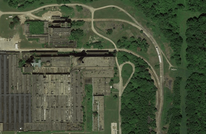
Also keep your eyes out for odd shapes and anomalies in nature. For instance, perfect squares, triangles, and circles are uncommon shapes. Finding patterns or shapes could indicate there might have been human activity in that area.
Look closely at the picture below, does anything catch your eye?

This is actually a flooded nuclear bunker located in a remote wooded area. Note the near perfect square shape. You can see where the cave in occurred filling the tunnel and basin with water.
To the south it’s likely this was the staging and construction area for the bunker. Often times these projects were disguised as logging operations or other commercial activity.
In rural areas, (at least in the United States) it is fairly common for families to keep their childhood home on their property and build a new house nearby.

I have seen newer homes share property with homes built in the early 1900s completely sealed like a time capsule. These are personally my favorite finds.
But do your homework!
Never assume a building is completely abandoned until you’ve scouted it on foot.
I have accidentally walked into hoarders homes, partially active factories, and completely occupied houses before..
If a spot looks like abandoned, mark it on your map and scout it out first.
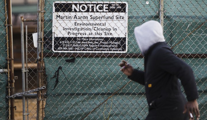
Abandoned Superfund Sites
No, not Superfun sites.
Superfund sites.
I’ll start by saying that this can be dangerous and you should only go this route if you’re an experienced explorer who has worked in dangerous environments and has thoroughly done their research of the site. I cannot stress this enough. Not having a correct understanding of the dangers and using the correct gear could literally kill you.
So what is a superfund site?
A superfund site is an area of land that is contaminated in some way, and deemed an environmental hazard by the EPA. The EPA usually reports the hazards and their plans to clean it up.
Some sites may still be active depending on their severity, and others will be permanently closed. You’ll get a list of sites ranging from plots of vacant land to factories where nuclear material was processed. The dangers range, and that is why I cannot stress enough that these places are not to be taken lightly.
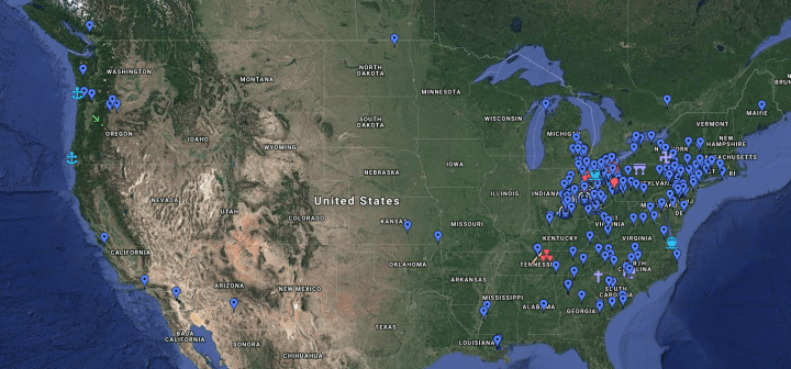
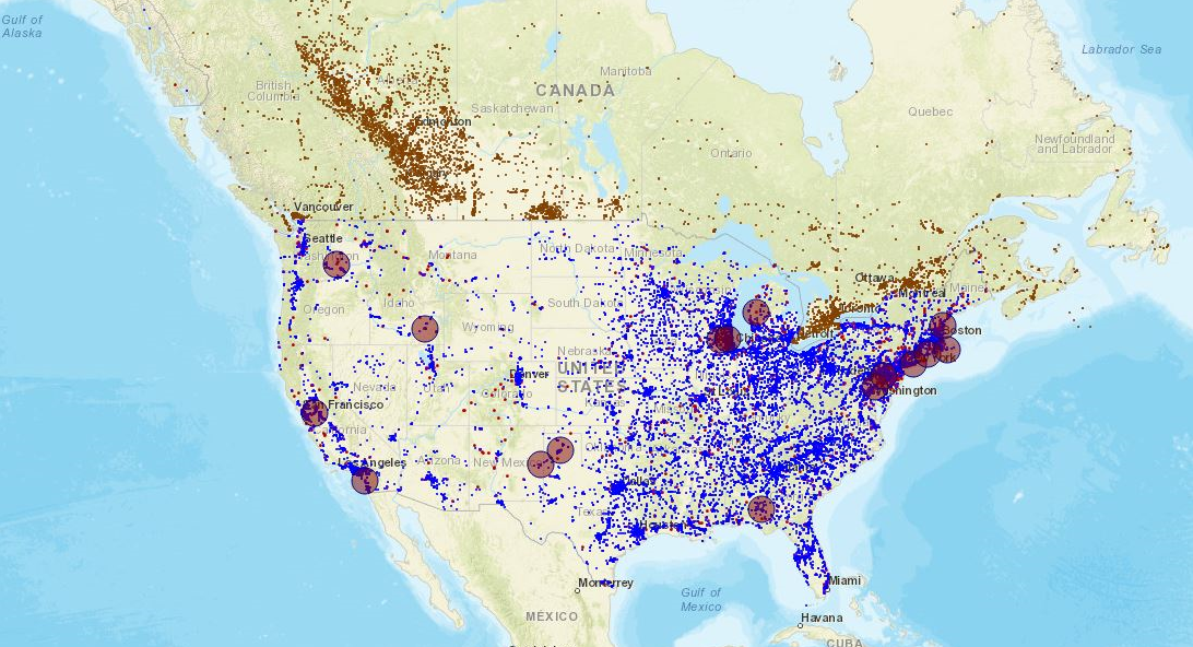
There’s an excellent tool called TOXMAP created by the National Library Of Medicine that allows you to search the entire United States for these clean up sites.
You can sort by contaminate and/or location to get a better idea of the area. Not all places are abandoned so it requires some research. You can also get a solid understanding of what took place and what to protect yourself against while on site.
Map of superfund sites based on levels of chemical release/contamination.
A lot of the contamination will be heavy metal and ground water based, but bring proper equipment when entering hazardous areas.
According to their site TOXMAP will be taken offline Fall of 2019. I am not sure what will happen to this data or if it will be available after that time.
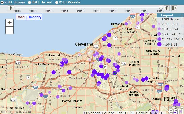
Additionally you can look to the NPL list which is the National Priorities List. This is a list of sites deemed to be a top clean up priority by the EPA. I personally have found abandoned chemical plants, power stations, and other miscellaneous sites this way.
If you’re not located in the United States, chances are your government also has publicly available data about clean ups.
Leverage Your Contacts
It’s never been easier to make friends and reach out to other explorers in the community and learn how to find abandoned places.
There is a right and a wrong way to do this, so I will briefly cover how to properly reach out and learn about new locations. You can find new locations to explore, as well as make a few friends.
If you have no friends in the exploring community, or maybe you’d like to meet others with the same passion, it’s now easier than ever.
I might be showing my age here, but when I first started exploring as a hobby, I didn’t even know it was a thing that other people were interested in.
After a lot of stumbling I came across a site called infiltration.org, now more widely known as Urban Exploration Resource or UER.

No matter what forum, Facebook group, or Instagram page you decide to follow or join, keep these few things in mind..
Introduce yourself and add value. Share places you have been, stories, and photos with the community. People are secretive about this hobby for a few reasons, one being that the more people know of a spot, the more likely it is to be resealed, or burned down.
Nobody wins and it’s why I choose to not disclose certain places publicly.
Some people also want to keep places private because they want to be cool.
With the dawn of social media more and more people want to have the best photos and not share locations with others out of pure vanity. Its sad, but a true fact of some people in the urban exploration community.
If you lead with value and find other people like you in your area, you’re bound to exchange locations and even make a friend.
I’m not saying run off into abandoned buildings with a stranger, I’m saying that the opportunity is there, you just have to bring something to the table first to show you’re not another mooch.
Abandoned Places On Wikipedia
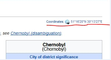
To some this might seem like common sense, but a lot of buildings that are abandoned have wiki pages that literally give you coordinates as well as the buildings entire history and current status.
I have used Wikipedia countless times to confirm a site’s location, as well as check up on its current status.
You can perform filtered searches on Wikipedia or other websites by using what are called search operators.
For example site:wikipedia.com “abandoned” will filter your search query to only pages on wikipedia.com that mention the term ‘abandoned’.
You can do this with any site, and any keyword. Get creative and see what you can find.
Once you find a page check the page for an address or GPS coordinates. Usually you’ll find this in the top right hand corner. From there, click on the coordinates and it will direct you to several flavors of maps you can open the coordinates from.
Lastly you can use Wiki to check the current state of the location. This isn’t nearly as reliable as having boots on the ground to confirm the locations status, but if it’s a great place to start.
How To Find Abandoned Places With Historic Lists
You’re not the only nerd who loves old things.
Chances are, a group of equally passionate people have compiled a list or map of old buildings, trains, military bases or whatever peaks their interest. This is honestly a treasure trove of not only information, but history that is often recalled by people who used to work or live in these areas.
For instance, I remember finding an old Nike military base in the woods. I had no idea what it was until I asked a few other explorers. Upon further research I found that nearly every single Nike missile base was listed and categorized online.
Everything was documented. When it was opened, when it was closed, what types of missiles were housed there, and sometimes who was even stationed at these bases.
Veterans exchanged stories about working at the missile bases during the cold war, describing what is was like to be there at that time. It’s a great resource to double back on and even interview people who spent time at these places (if you’re a history geek like I am).
It was amazing to see how close I was to other bases that were abandoned. Some sites were paved over, while others were converted into homes, or museums. I’ve done this with shipwrecks, military bases, train cars, and even old amusement parks.
Get Cozy With A Realtor
Don’t really snuggle a realtor, but they do have access to information about buildings that is not publicly available. They have a database called the MLS which stands for Multiple Listing Service.
This database requires you to hold a realtor license in order to log in. It contains both commercial and residential properties that are on and off the market.
I can’t say I’ve used this method a lot, but if you have a friend who is a realtor they can easily pull up properties that are listed as foreclosure, have a ton of back taxes owed, or have just been sitting on the market for years.
If you don’t have a real estate pal, you can look to sites such as Loopnet to find properties that may be foreclosed. You can sometimes find entire factories listed for millions of dollars that have just been sitting vacant.
Make them an offer they can’t refuse.
Set A Google Alert
This is a new method I’ve tried recently that has helped me get into some abandoned places right before they were demolished. Set a Google Alert for a location that you think is going to get demolished or is going out of businesses.
Google will alert you anytime a keyword phrase is mentioned online. For example, “ABC Mall demolition” or “ABC Mall foreclosed” could be used to alert you when news articles are covering specific places that have recently gone out of business, or are in decline.
While this method isn’t the best for finding places right away, it’s a good tool to have for those places you can’t keep tabs on all the time.
How To Find Abandoned Places (Advanced Search)
I touched on this a bit before but I saved the best for last.
If you’re still wondering how to find abandoned places, and you’ve tapped out your circle of friends try some armchair exploring by using those advanced search operators I talked about earlier.
Why is this so powerful?
I debated sharing this, but I guess it doesn’t take a brain surgeon to figure this out.
Not everyone secures their personal Google maps, sometimes they get shared incorrectly, or a just made public by who ever made them. Once public, they get indexed by Google.
That means we can search for them.
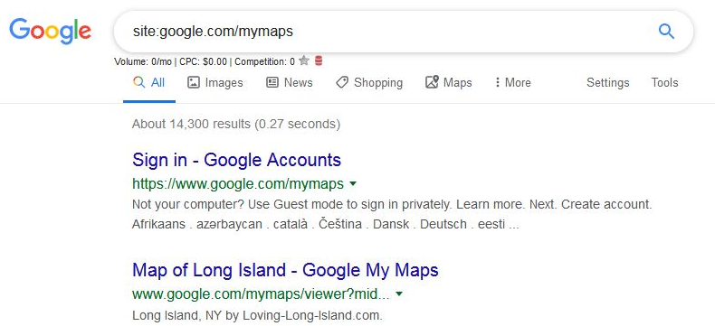
By typing site:google.com/mymaps “keyword” we can search by keyword every single public Google map.
I have found nearly a half dozen exploring maps that were public. The great thing is, you can easily download the KML file in case the owner deletes it.
Below you can see that there are a little over 14,000 public maps. Not all of these are related to exploring, but this has definitely helped me come across some very detailed and accurate maps of drains, shipwrecks, and abandonments by other explorers.
If you really want to put on your detective hat (and this might be going a bit overboard) you can find out the financial status of any property. Anywhere.
If you cannot physically check it out in person or use any of the other methods you can check to see if the property owes a lot in backtaxes.
For instance, if you see a place on Google Maps, and it looks like it’s overgrown but you’re not 100% sure, you can check to see if anyone is paying their taxes on that property. 9 times out of 10, people who abandoned their property don’t pay the taxes on it.
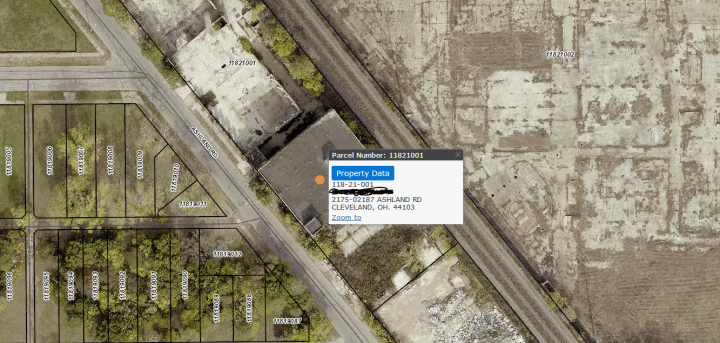
Google “*your county GIS*.” A search example would look something like “Hamilton County GIS”.
If you’re in the United States pretty much every county has a database of every property and it’s current tax status. This is the same strategy real estate investors use to get information on land and buildings.
If you did it right, you should have a map and a bunch of lot numbers. Below I see a building, I’m not 100% sure if it’s in use or not.
Lets check its tax status to find out more!
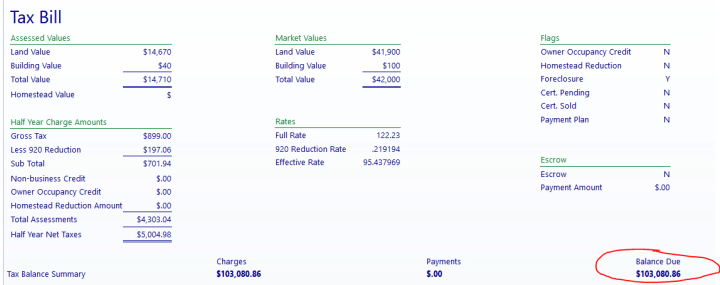
This is what 20+ years of taxes looks like guys..
There is a lot of information on this page, but the main thing we’re looking for is if it’s listed as a foreclosure, and how much it owes on taxes. With this additional information, and what we could see on Google Maps, it’s safe to assume that yes, this property is vacant.
I hope you genuinely learned something new, there are little to no real resources for people who want to learn how to find abandoned places, and I’d like to fill that gap.
If you’d rather get permission be sure to check out my article on the best ways to get permission to explore abandoned buildings.


